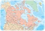
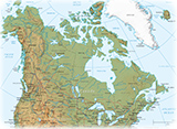
Political Map of British Columbia - Canada
More: Images of Canada ►
British Columbia is the westernmost of Canadian provinces. It is bounded to the north by Yukon and the Northwest Territories, to the east by the province of Alberta, to the south by the U.S. states of Montana, Idaho, and Washington, and to the west by the Pacific Ocean and the southern panhandle region of the U.S. state of Alaska. British Columbia is Canada's third-largest province in terms of total area, after Quebec and Ontario.
The area now known as British Columbia is home to First Nations groups that have a deep history with a significant number of indigenous languages. The name of the province was chosen by Queen Victoria, when the Colony of British Columbia (1858–1866), became a British colony in 1858.
British Columbia's capital is Victoria, at the southeastern tip of Vancouver Island. The province's most populous city is Vancouver, which is at the confluence of the Fraser River and Georgia Strait. British Columbia contains a large number of provincial parks, run by BC Parks.
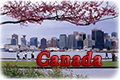
Event in Victoria, British Columbia.


|
Copyright © Geographic Guide - Maps World, North America. |
|